
More than ever before, municipalities are working to build digital models of their sewer networks that reveal the intricacies of both form and function. GIS mapping software has become an essential tool in this endeavor, and for many sewer professionals, Esri’s ArcGIS stands out as the pinnacle of geographic information systems.
By enabling the modernization of workflows in the field and the office, ArcGIS provides powerful insights regarding the location, condition and interconnectivity of sewer systems, and those insights are compounded by valuable integrations with WinCan VX.
Paired with WinCan, Esri’s ArcGIS can help engineers and operators identify the proximity of sewer pipes to surface features, pinpoint manhole locations and quickly track down, view and edit section data with the click of a button. Using a bidirectional integration, users can either pre-populate WinCan projects with data from ArcGIS or bring completed inspection data into ArcGIS for analysis, making it easy to navigate both platforms without changing workflows.
Partnering With Esri
Since partnering with Esri in 2017, WinCan’s integration with ArcGIS has expedited and streamlined inspection workflows for municipalities around the globe. It has proven to be one of the most flexible and well-integrated inspection solutions on the market, and with two industry powerhouses backing their workflow, users have the ability to get more done, faster. In particular, WinCan’s partnership with Esri has created new opportunities for sewer professionals to track and visualize their data, helping inspection teams gain valuable insight and allowing them to quickly and efficiently make more informed maintenance decisions. 
By bringing inspection data into a broader GIS system, inspection teams have the ability to share data with other municipal departments, enabling an interdisciplinary workflow that extends beyond wastewater. Furthermore, WinCan gives users the ability to populate Esri with field observations about the asset itself such as pipe size, material, shape, etc. If operators find that a pipe has a material different than what’s noted in the GIS system, WinCan’s integration allows them to detect the differences and merge the new data into Esri. This increases both the completeness and accuracy of the primary GIS system, all while performing routine inspection work.
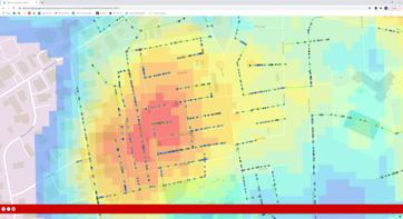
Because Esri’s mapping capabilities are so robust, WinCan users can easily analyze any amount of infrastructure data in ArcGIS. From there, heat maps give a clear picture of a system’s condition and criticality, while easy-to-understand iconography provides the scope of local geographical features. This helps inspection teams save time and money by avoiding unplanned costs and unexpected complications during inspections or rehab projects.
"WinCan's integration with Esri opens the door to bidirectional data transfer that expedites inspection workflows so that operators in the field don't need to worry about data re-entry," says Mike Russin, general manager of WinCan for the Americas. "It ties the best of the GIS platforms with the best of inspection software to create a robust solution that meets the needs of users on the job site as well as in the office."
How to Use the Esri Integration
Due to the seamless integration between WinCan and Esri, building ArcGIS into your workflow is simple. If your team doesn’t have the personnel to coordinate integration support on their own, WinCan’s Sewermatics offers data visualization services that help ensure peak functionality and connectivity between both platforms. Furthermore, ArcGIS gives you the ability to bring a WinCan toolbar directly into the ArcGIS user interface, granting you immediate access to your inspection data.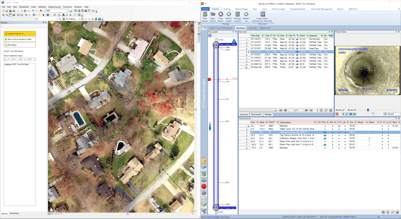
Once you have both platforms up and running, the WinCan support team can provide you with the necessary files to set up your WinCan toolbar. The toolbar can be added during initial setup of ArcGIS Pro via the ArcGIS Administrator, but if you already have ArcGIS installed, you can connect the WinCan toolbar via Customize > Add-In Manager.
When the WinCan toolbar is ready to go, it’s time to configure your WinCan project in Esri. Start by clicking on the “Add Data” button in the ArcGIS toolbar to bring in any aerial imaging from your WinCan project. This ensures that visuals are clear, accurate and ready for inspection data to be overlaid.
Pro Tip
When you import aerial images, group them by ensuring they are all selected, then right-click and select “Group.” You’ll have the opportunity to name the group, making it easier to track down and use.
Now, it’s time to initiate connectivity with WinCan. Open VX and your inspection project, then hop back into ArcGIS. From there, all you need to do is navigate to the WinCan toolbar, click “Connect WinCan VX” and sit back as your WinCan project data populates in Esri’s ArcGIS.
Not only does the partnership between Esri and WinCan allow for valuable data visualization, but shared integrations have the ability to enhance and streamline the inspection workflow from start to finish. No matter which platform your team builds their workflow around, the ease of data migration ensures inspection teams have more information at their fingertips, saving time, energy and money in the office and in the field.
Learn more about WinCan’s integrations by requesting a free demo of WinCan VX or schedule a consultation with our Sewermatics team for data visualization services: