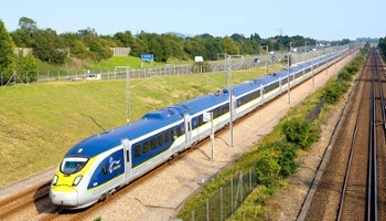
The High Speed 1 (HS1) route formally known as the Channel Tunnel Rail Link (CTRL), is a 109-kilometer (68-mile) high-speed railway between London and the United Kingdom. The HS1 is used for domestic and international train services as well as transporting freight.
 As with all such engineering constructions there is far more to the successful running of the HS1 route than just getting the trains from A to B at the required times. To keep the trains operating to schedule there is a significant amount of ‘behind the scenes’ work that needs to be undertaken on a daily basis. Not least of this is the need to ensure that track, earthworks and structures have fully functioning drainage irrespective of the prevailing current or expected future weather conditions.
Due to the railway being a relatively modern route, the HS1 infrastructure has the opportunity to operate under different and more relevant operating standards and asset data storage systems to those used by other infrastructure managers which may have to manage assets that may be over 100 years old. Therefore, it is more appropriate for Network Rail High Speed Ltd to utilize a different approach with regards to drainage management. According to Thomas Morgan, Asset Engineer with Network Rail High Speed: “One thing that we ensure we do is that we share best practice where appropriate with our industry and railway partners to support and assist in future innovation.”
Network Rail High Speed has been monitoring and analyzing the degradation of railway assets, including drainage assets that will allow the use of quantitative data to determine appropriate intervention points for asset maintenance and renewal operations.
Having investigated a number of potential software options both domestically and internationally, Network Rail High Speed was looking for a strategic solution that would enable engineers to visualize assets and asset condition and to identify a suitable platform to support future maintenance records. Network Rail High Speed’s preferred option was a GIS system underpinned by a database.
Ultimately the search brought Network Rail High Speed to WinCan which at the time was finalizing development of its latest CCTV reporting software WinCan VX as well as its WinCan Web remote storage and access facility and its WinCan Analyst and WinCan Map support systems. Discussions with WinCan highlighted how working together in the development of a specific system suited to the requirements of Network Rail High Speed would provide the strategic solution needed by Network Rail High Speed.
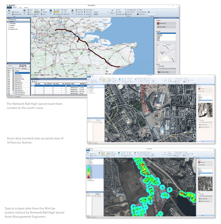
At the time Network Rail High Speed operated its asset management utilizing some 250 survey DVD’s and their associated reports. WinCan was able to convert this historic drainage data and CCTV video into the latest WinCan VX format and produced a GIS model which can be interrogated to determine asset type and condition.
Network Rail High Speed has to manage some 225 km of track drainage with over 10,000 drainage assets, which includes a significant amount of under-track structures such as culverts etc. as well as the main track drainage system. The implementation of the new WinCan suite has allowed the organization to visualize the entire drainage network using the latest available information and heat map drainage assets with regards to hydraulic and structural defects. This has enabled engineers to understand how the drainage network performs across each drainage catchment area.
Thomas Morgan said of the system: “This now allows us to prioritize our drainage maintenance works and support and inform our future drainage management strategy to ensure that our budget is spent wisely. The WinCan suite allows us to implement targeted maintenance on our most critical drainage assets and efficiently identify any defect ‘hotspots’ which require maintenance activities to be undertaken prior to any potential service affecting faults to be realized.”
The WinCan Web software also allows Network Rail High Speed operatives to see accurate records in real time on site, via iPad/Tablet applications to enable an informed decision on how to rectify any reported defect. From a strategic point of view for Network Rail High Speed, the WinCan Analyst and Map tools allow decisions to be made on drainage maintenance and enables the planning engineers to export map layers to Network Rail High Speed’s own GIS route model, which was a key requirement for any new drainage asset management system.
Integrated access when needed
Where the traditional reporting systems fall short of requirement is that they are often paper / DVD / Video recording based and can be difficult to access without significant time and effort on the part of the engineers concerned. This may lead to assets being examined not on an ‘as and when required’ basis but on ‘rotation’ as that asset comes to the ‘top of the pile’ with potentially some defects not being recognized at an early enough stage.
The availability of the WinCan Web, Analyst and Map software means that new surveys will be accessible more quickly with ability to highlight potential trouble spots.
The WinCan’s Analyst software tool offers a good visualization of active location conditions and can highlight local hotspots that may need further investigation or maintenance work before they become a significant problem. Any additional survey works that may be required to supplement the original data collection and confirm any potential problematic areas in the network can also be uploaded to the WinCan Web system as and when required.
WinCan Analyst is a software system that is able to evaluate, manage and analyze sewer networks. The software is based on the WinCan VX platform, which secures a direct integration of the inspection data to the analysis, without a need to interchange the data, which could reflect in loss of specific information (like inclination measurement). One of the main values of WinCan Analyst is the seamless integration into different GIS Systems and the optimization for high performance, also with high data volume. WinCan Analyst contains different functional areas: Management of status data of the sewer systems including their automated classification, analysis of the characteristics of the sewer systems in GIS systems, issue of statistics and reports as well as maintenance and rehabilitation planning for pipes and manhole systems.
The WinCan Map VX system is a geographic information system for sewer networks. This software allows engineers to navigate and analyze inspection data using familiar GIS views and tools and Map VX accepts all major GIS data formats including ESRI, AutoCAD, DXF/ DWG, MapInfo, OpenStreetMap, etc. or as in the case with Network Rail High Speed its own in-house mapping system.
This highly flexible interface offers easier interaction where it can group interface elements according to function, resize them, and turn them on or off with interface customizations that can be saved for easy recall and sharing. Also when an asset position is unknown, WinCan Map VX can accept coordinates directly from a GPS unit and map it.
In terms of data visualization, WinCan Map VX offers color-code map elements according to asset attributes (material, age, profile, damage classification, etc.), and can then save those preferences as a template. Several standard templates also come with the software. Given that during a mainline inspection, important information is gathered about lateral connections such as location, angle and clock position, WinCan Map VX can also use this data to display laterals on GIS maps, and to export them to DXF and Shape files and the whole process is fully scalable.
Summarizing Thomas Morgan said: “With the WinCan software suite Network Rail High Speed is confident that it now has the correct platform to record future maintenance activities and support and inform the future proactive drainage strategy for the route. Some 98 % of validated drainage data is now up and running on the new WinCan system already from the historic data that WinCan has reformatted for us, and we now have the right platform on which to build and to make future updated information effective.”
For WinCan, Paul Woodhouse said: “We are very pleased to have been able to work with the Network Rail High Speed team to develop a product that will enable them to manage, plan and implement their drainage works based on current and easily accessible data without the need to ‘man-handle’ reports as has been necessary in the past. This type of situation is precisely the sort of operation that WinCan Web has been designed to handle quickly and effectively. We will of course be available to offer any support that is necessary to the Network Rail High Speed team as the new WinCan system develops further.”